Thursday, June 1, 2017

My favorite walk in Mount Carmel Junction, UT

I loved this walk.  The first time I went, Don, Lyn and Larry were getting ready to go and invited me along.  It was actually right across the highway from our camping area.  Easy, peasy!  You just walk across the street, down the road toward the river, and follow the road until there's a kind of left turn.  As you walk the short distance on that left turn road, you come to the end, which is a tunnel.  Climb down, walk through the tunnel (bring a flashlight), and out the other end.  A short walk later you're at a wall with a little waterfall.  Really cool!

I think the story was that they needed to build a new road, and rather than moving the location of the road, they decided it would be cheaper and easier to just dynamite under the road and put in a tunnel, so the flow of water to the Virgin River would continue as before as it came down out of the hills toward the river.  So that's what they did.  And I think they moved and enlarged the road, too, but still right over the tunnel.

The first time I went, the four of us walked back out of the tunnel and down along the road alongside the Virgin River.  We got to a point where the river crossed the road, and we'd be wading in the river to get to the other side, so we stopped there.  (There's a ranch further along the road.)  We hung around for a bit, then turned around and walked back to camp.  Easy hike, really a walk, with some interesting things to see.  Wish I had brought my camera that time.

Larry noticed some strange things in the water at the edge of the river, they looked like thin rope pieces floating back and forth in the water.  We all checked them out and decided they were egg sacs.  When Don and I went back the next day, the egg sacs were still there, surrounded by tiny black specks - we thought they must be the eggs.  I should have gone back to that point again to see what happened with the eggs, but my next two walks down the road didn't go that far.

I took that walk four times in four days.  The first time I wasn't prepared, so didn't have my camera.  The next morning I went with Don, we walked along the river to where the road was under water and I got some Virgin River photos and the little black eggs.  Then the next afternoon I went back with Katie, but just to the tunnel entrance because I didn't want to lift her down to the tunnel floor by myself.  We didn't walk down the road further because of her arthritis.  The next time I went with Nancy and her dog, Dolly.  They are both great walkers.  I left Katie home that time, and we did the tunnel and part of the way along the river.  There was an unleashed dog down the road, and we decided to turn around when we saw him.  So each walk was different, and I loved every one.

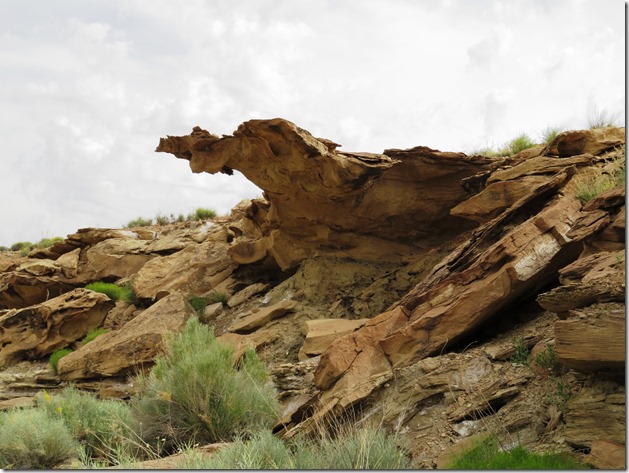
The pictures I have below are all in order as far as the sights and locations go, but from different days, starting with walking down the road to the tunnel road, walking through the tunnel, going to the waterfall wall, heading back out through the tunnel again, and walking down along the Virgin River and ending up at the end of the road where it goes under the river - with the egg sacs and black eggs.  Four days combined into one.  Hope that makes sense.

Heading to the tunnel:


Here's Katie, checking out the area:

This is where you have to take a BIG step down to the tunnel entrance.  I didn't' want to lift Katie down, but when I went with Nancy and Dolly, I went down first and Nancy handed Dolly down to me.  That worked great.

Here's the opening to the tunnel:


On the ceiling right at the opening were a number of bird nests made out of mud.

Nancy took this shot of me - notice my big smile!  LOL  Actually she took a couple more facing into the tunnel, but I wasn't being very photogenic, so I scrapped those.

Here's the view as you start walking into the tunnel.  Looks like a huge intestine - sorry, you won't be able to get that visual out of your mind for a while.  😖

It's a short tunnel, but there is a dark portion, so it's a good idea to bring along a flashlight.  There are a couple of spots where you step up and over a raised part, and some loose rocks on the tunnel floor.  Plus, it's just cool to see.


Here's Nancy and Dolly - you can see the "light at the end of the tunnel" further on.


When you emerge from the tunnel, there's a short path to the end.  It stops with a wall that has a tiny waterfall.   Where else do you get a river, a tunnel and a waterfall in such a short walk?  (Every time I read this line I can barely hear lots of WINs' voices in my ears yelling all the different hikes they've taken where they saw a river, tunnel and waterfall in an even shorter walk.)
🙃


After checking out the water and rocks for a couple of minutes, we turned around and headed back into the tunnel:


Coming back out of the front of the tunnel this is what you see, a short little wash that allows water coming down from the waterfall in wet weather to flow through that large pipe and into the Virgin River on the other side.


This is the Virgin River, flowing along on a beautiful sunny day.  It goes all the way to and through Zion National Park.   Per Wikipedia: The Virgin River is a tributary of the Colorado River in the U.S. states of Utah, Nevada, and Arizona. The river is about 162 miles long.


This is on the day I walked along the Virgin River with Don - Hey Don!  Turn around!

That's better.  :)

I never did cross the road under the river, but on a couple of the days I was there I talked to ATVers who were riding up and down that road, going through the water.  They were fun to watch.  Some were very careful when they got to the water, and some were Hell Bent for Leather, blasting through it.  Different strokes for different folks, I guess.  And one bad metaphor and one bad metaphorical proverb from me. (Had to look that up, I didn't know about metaphorical proverbs - what does that even mean?)

The second day Don and I looked for the egg sacs and found them.  They looked a little different, and were all surrounded by tiny black specks.  We figured those must be eggs.  The first photo is what the area looked like, and the second and third are close-ups.  We wondered what the eggs would hatch into.  Any ideas?


It was cold, and snowed a little on Thursday afternoon.  I was expecting rain, so I went outside to fold my chairs and put them under The Palms.  When I looked at my chairs, they had snow on them.  :(

The next morning, on Friday, everything was covered with frost.

It was COLD!  Actually, it was FREEZING! 


There's Lyn's Class C in the front, Don's trailer in the middle and Nancy's Lazy Daze in the back.  I'm parked across the road from Lyn, right behind where I'm standing to take this photo.


This was my indoor/outdoor temperature gauge, showing the outside temps a little before 9:00 am:


One of the things that's nice about being a full time RVer is that we have wheels under our homes.  I'm sure most of us have woken up in the morning and decided on a moment's notice that we're leaving.  That's what I did that morning.  I didn't mind the cold and lack of Internet or cell service for a while, but the WINs were heading north.  I was heading SOUTH.

I went to the morning meeting, said goodbye to everyone who was there, walked over to Nancy's motor home and told her I wasn't going to continue at this point, and was heading back to the Flagstaff area.  She and I had made plans, but...  I'm sorry Nancy.  I just needed some warm weather and familiar surroundings right then.

So off I went.  And that's where I am now.  Happily under pine trees, camped next to a lake just south of Flagstaff, AZ.  More from my new campsite next time.

From me and Katie, have a great day, everyone!  😊😎😘😊

Sunday, May 28, 2017

Moqui Cave and Best Friends Pet Sanctuary

The next stop on the WINs travel plan was Mount Carmel Junction, between Kanab and Orderville, UT.  Kanab is a fairly good sized town, Orderville smaller, and Mt. Carmel Jct. was a tiny spot right down the road from our campsite. 

We didn't have Verizon where we were camped, so no phone or hot spot Internet, but I was able to text.  However, the little town of Mt. Carmel Jct., which we could see from our camping spot, had free WiFi at the Thunderbird Restaurant, an easy walk down the road.

Two of the activities planned that I went on were fun and interesting.  Some of us planned to visit the Moqui Cave in the morning, then have lunch at Best Friends Pet Sanctuary and take their tour afterward.

First was Moqui Cave.  (Click this link for more info.)  I went with Elaine, Jan and Larry, who took this photo of us girls in front of the cave entrance:


 And here's Jan, Larry and Elaine in another entrance shot:

I took a picture of this picture hanging on the wall in the cave.   This is what the opening to the cave looked like in the old days.  A hole in the wall - compare that to the shot above.


As you walk into the cave, there is a foyer type room with lots of interesting things on display:


I have to apologize for my pictures of this outing - there was so much to see, so many different kinds of artifacts from dinosaur tracks to Pittsburgh Steelers memorabilia, to Hollywood film photos, and the display of fluorescent fossils and minerals, etc., that I was engrossed in the experience and didn't take many shots.  It used to be the only open bar serving liquor in Utah, and the bar and stools are still there, too.  It has been in the family for three generations now, and the collections are many.  So much to see! 

The cave was bought by Garth and Laura Chamberlain in 1951, and they made continuous improvements and additions through the years, with their five children helping them.  One of their sons, Lex, and his wife, Lee Ann, took over when Garth died.  Some of the WINs met Lex last year when they toured the cave, but unfortunately he has since died as well.  His daughter was our tour guide when we went through, and she knew the whole story from the beginning of the cave's history to when her grandparents bought the property, to when her parents owned it and made more improvements, to current days - she was very knowledgeable and interesting.   I'm sorry I didn't get her name - beautiful girl, she gave us a great tour.


They are making some improvements outside the cave, and this guy looks like he's a new addition.  As we drove by from time to time (they are right on the highway into Kanab), I could see brick walls going up and lots of building activities going on.


Entry price for Moqui Cave is $5, or $4.50 for Seniors.  Well worth it!

Next we drove on to Best Friends Pet Sanctuary, where they offer a $5 buffet vegetarian lunch.  It was really good, and I ended up going back another day just for the lunch!  You can sit inside or out on the large deck with a panoramic view of Angel Canyon. 

After eating we went to the visitors center to watch a brief video and then catch the van for our tour, which we had reserved (the tour is free, but they want reservations to make sure they have enough tour drivers and vans available).  In front of the visitors center was a beautiful pond with a waterfall, benches, lots of plants and shade - a nice place to sit and rest.


From their website:  "1984: The founders of Best Friends Animal Society break ground on their no-kill animal sanctuary in Kanab, Utah. It becomes the nation's largest no-kill sanctuary and Best Friends becomes the flagship for the no-kill movement."

Our driver/tour guide drove us all over the grounds, which were enormous.  She told us about the facility's history and what each building or area was for - these are the animal areas:
There are also two pet cemeteries, Angel's Rest and Angel's Overlook.

Best Friends is home to about 1,600 homeless animals from tiny guys to horse size critters:  dogs, cats, birds, rabbits, horses, pigs, goats, mules, sheep, burros and wildlife.

All these critters are homeless, and many are ill or abused and in need of loving care and a good home.  If a home is not found for them, for any reason, they have a safe haven there for the rest of their lives.  Kind of brings tears to your eyes, doesn't it?  What a great place this is.

First stop where we could get out was at the Puppy Care Center.  We were lucky to be there when they had some puppies that we could visit:


We also got to go into Cat World where a lot of cats were lounging, walking around, checking out their new visitors, etc.

Look at all the food bowls and dishes drying on the counter:


Here's Jan - she had two cats come up to her and chew on her shoelaces, one on each shoe.  (Obviously they could tell she was a cat girl, although she has two dogs.) It was funny, then one of them wandered away.  As the other was still chewing, Jan bent down to pet him and got a ferocious swat on her hand.  It left a scratch that must have hurt.  She was a good sport, but I was feeling her pain.  Cat scratches are not fun!
 

Toward the end of our tour we got to see some of the larger animals.  Horses, donkeys, burros.

Our guide pointed out the horse below with the sway back.  She said not to feel sorry for him, he feels just fine.  He has equine lordosis, which is a congenital spinal condition where the thoracic vertebrae at the wither do not develop properly.  Horses with this condition don't appear to be in pain, and she said this horse is doing just fine.

The brown horse in the middle in the photo below also has a condition - I forget what it's called - where her tail and mane hair is missing.  Again, she is not in pain, and the guide said she has a habit of trying to nibble on the tails and manes of the other horses.  ??  They don't know why.  Poor thing.

There are two burial sites for the animals who die - Angels Rest and Angels Overlook - one is for the resident animals, and the other is a resting/memorial site for the pets of the people who live in the area.  They are full of wind chimes that tinkle when the slightest breeze blows.  


The gate above was made by a man who made gates to all the different areas, with each showing what the area is, like cats on the Cat World gate, and dogs on the Dogtown gate.  Each was unique and beautiful.  If I remember correctly, he donated all the gates to Best Friends. 

The facility and all the work and loving care that happens here is set in the gorgeous red rocks and green trees of Utah, everywhere you look is a photo op.


This was an interesting story our guide told us.  There are a LOT of volunteers needed to keep the facility open and operating.  She said there is one volunteer who felt that there are lots of people who want to help with the animals.  She said he's right - many do hands on work, some walk the dogs, some play with the cats, some do clean up, others do laundry for the hundreds of blankets that are washed and dried each day, etc. 

Well, this man said he wanted to clear the walking paths of stickers where the animals were exercised by volunteers.  So he covers as much ground as he can each visit along the dirt paths and walkways, picking up every goathead and any other sticker he sees that might end up on an animal's foot, or stuck in their pads.  

Katie has stepped on goatheads, and so have I - and they HURT.  Can you imagine the selflessness of this man, spending his volunteer time bending over again and again and again, picking up goatheads, thorns and stickers so the animals can have a pain-free walk?  He truly has a good heart.  💖💖💖

"Best Friends owns nearly 3,700 acres, and we lease another 17,000 acres of state and federal land. Nearly 30,000 people visit every year to meet the animals and tour what has become the nation's largest no-kill sanctuary for companion animals." 

They are located at Angel Canyon in the beautiful red rock country of Southern Utah, just outside the town of Kanab.  There are lots of beautiful photos of Best Friends here.  And more information about Best Friends Pet Sanctuary here if you're interested.

If you are in the area, don't miss the delicious $5 lunch or the wonderful guided tour of Best Friends. (Don't forget to make a reservation - the guided van tour is free.)  You won't be sorry, I promise. 

From me and Katie and all the friendly critters, have a great day, everyone!
😊❤😸🐶🐭🐷🐰🐸🐔🐏🐃🐴🐐🐢🦃🦎🐍❤😊

Friday, May 26, 2017

Wiregrass and Wild Orchids

Two more hikes while at Lone Rock Beach

1.  Wiregrass

While we were at Lone Rock, there were lots of different hikes scheduled.  One of the hikes I chose was called Wiregrass, it was offered as an easy hike.  It was fun when we started out - lots of climbing up and down rocks, and pretty flowers along the way.


Some of us only hiked part of the way.  Our leader (who knew the way) and another hiker got ahead of us, but we were able to catch up.

Then they headed over to this canyon and descended to the bottom and were in the wash before we could get to the rim to see which way they took to get down.
 

Four of us just stood there, looking at them down in the canyon and at each other.  We were yelling down, asking: Which way did you go?  I don't know if they heard us, but we didn't get a response.  I didn’t take a photo from the edge, but it was deep and I didn't see any way down! Finally one of us said, “I’m not going down there.”  Whew!  (I was thinking, "I'm not breaking a leg!")  We agreed to head back to the car and go to another hiking location on our own.  We yelled down that we were heading back, and they continued on with their hike.  Luckily we had two cars.  

This hike is listed on the National Park Service website as a moderate hike, but up until we turned back, it was easy with only a few places where we had to scramble, which I think made the portion we did more fun.  Maybe next time I'll go further and climb down into the canyon wash.  😉


As we walked back to the car I got more shots of the beautiful scenery.  I'm sure the men who went on with the hike got some great photos that we missed.  But I'm usually pretty risk-adverse, and this looked a bit risky for me at this point.

We all jumped in the car and headed to Hanging Garden.  This was one of the hikes that I especially wanted to take, so I was glad we all agreed to head over there.

"Wiregrass Canyon
From Page, drive north on Hwy 89 approximately 12 miles (19 km) to Big Water, Utah. Between mile posts 7 and 8 (at the Big Water Visitor’s Center), turn right (away from the VC). Turn right again 0.3 miles (0.5 km) from the junction of Hwy 89 - there is a sign at this intersection which reads “Glen Canyon Nation Recreation Area – State Highway 12”. Drive 4.6 miles (7.5 km) to “Wiregrass Canyon Back Country Use Area.” Park in the pullout provided. Sandy wash, requires some scrambling and detours - look for rock cairns to lead you out.
6.0 miles (9.7km) round-trip
Moderate"     --From National Park Service Website 


2.  Hanging Garden 

This was an easy trail lined with rocks:
Hanging Gardens walk 2 
There were some beautiful pink cactus flowers along the way:
Hanging Gardens walk 1
The red rock surrounded us on all sides.
Hanging Gardens walk 3
Hanging Gardens walk 4
Hanging Gardens walk 5
Hanging Gardens walk 6
I’m not sure I’ve seen this flowering bush before, it was lacy and pretty:
Hanging Gardens walk 7
The other two women, Diana and Rose, walked on ahead,
Hanging Gardens walk 8 
and Bob and I slowed down to take some photos.

The Hanging Garden has both helleborine orchids and maidenhair fern living on the wall:
Hanging Gardens walk 9
It’s not large, but the fern area is taller than it looks in the above photo, way over my head. I had to reach up with my camera to get the overhead shots close up.  It's really beautiful.  The underneath protected part of this huge red rock has wild maidenhair ferns and helleborine orchids growing out of it. 
Hanging Gardens walk 10
Close-up of one of the orchids growing out of the ferns.
Hanging Gardens walk 12
Hanging Gardens walk 13
A little bit of fern growing from the overhanging rock ceiling:
Hanging Gardens walk 15
Hanging Gardens walk 14
We looked around, took in the area, snapped some pictures then headed back to the trail head.

"Hanging Garden
Turn off is one quarter mile (.4km) east of Glen Canyon Bridge (the opposite side from Carl Hayden Visitor Center) on Hwy 89. Trailhead parking is 500 yards (455m) off of Hwy 89. This hike leads you to a luxuriant Hanging Garden on the mesa top high above the Colorado River and Lake Powell.
Securely hidden by Jurassic Navajo sandstone, this seep spring quickly takes hostage every drop of rainwater it can absorb. Slowly it liberates this water over time to create a surprisingly lush plant and animal habitat that delights and surprises those who discover it.
The desert is astonishingly subtle and delicate. If you walk quietly, you will see and hear more. It can refresh observations and awaken inactive senses with each step you take.
1 mile (1.6km) round-trip   Easy to Moderate"     --From National Park Service Website


Looking out from the Hanging Garden - isn’t this beautiful?
 As we got  closer to the trailhead, we could see a boat in the water below.Hanging Gardens walk 16
Sure turned out to be a nice day!
 
From Me and Katie, have a great day, everyone!  😎😊🤔🙄😨😉